Medieval Itineraries: Matthew Paris
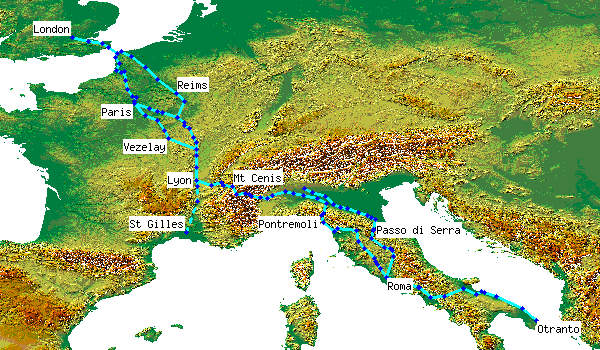
Matthew Paris was a monk in the Benedictine abbey of St Albans north of London. Of all the medieval itineraries, his is perhaps the most interesting, because it shows the places not as a textual list but as a primitive map. Dating from around 1250 with text in the French of the time, there are three main versions (only a fragment of a fourth survives, prefacing MS16 in the Parker library):
- the simplest, and possibly the earliest, is in the so-called Book of Additions (Liber Additamentorum), now in the British Library - Cotton Nero D I. It is a double-page spread occupying folios 183v and 184r, with the route as far as Chambéry on the left, and the rest on the right
- the other two preface versions of the Chronica majora:
- the main version of the Chronica in the Parker library of Corpus Christi College, Cambridge (MS26), folios 1r-3r
- the Historia Anglorum, in the British Library - Royal 14 C VII, folios 2r-5r these two occupy 5 folios, with an extra 2 for the Holy Land itself.
Although the basic route is the same in all versions, there is more detail in the larger versions, particularly in the Historia Anglorum, and more variations to the route. All give the journey times between towns (in days). In general, the routes can easily be followed on a modern road map, though the geography is wrong in places: the situation around the Appennines is confused, particularly in the Parker version, with towns shown seemingly at random, and the Apulian ports are also partly in the wrong sequence. The routes plotted here are an attempt to rationalise these into logical sequence, with two main routes through France to the Mt Cenis pass, two main routes through N Italy to Rome, and the Via Appia route on to Apulia.
More details
spreadsheet | detailed map (103 placemarks)External resources
All the versions can be viewed online. Those marked BLIO are available on the British Library Images Online site, which now requires registration; search for "Matthew Paris itinerary" and select the image you want.
- Book of Additions: catalogue entry; whole spread (BLIO); detailed view of verso/left half
- Historia Anglorum: catalogue entry; more detailed views of each folio on BLIO: 2r (London-Beauvais/Reims); 2v (Beaumont/Oise-Beaune); 3r (Chalons/Saone-Mt Cenis); 3v (Susa-Reggio/Emilia); 4r (Mte Bardone-Apulia); 4v-5r (Holy Land). More detailed versions are also on the collectbritain site: 2v; (2r currently not available); 3v; 5
- the complete Chronica Majora is available online at Parker on the web. You must register, but registration is free A transcription of the Historia Anglorum version was published as Iter de Londinio in Terram Sanctam in Konrad Miller, Mappa Mundi: Die ältesten Weltkarten, Stuttgart, 1895-1898, 6 vols, II, pp.84-90. There's a transcription of the London-Rome section on Giovanni Caselli's website and of the Rome-Apulia section in an article by Fabrizio Vanni on pilgrim itineraries for the south of Italy on the Centro Studi Romei site (p.36).