Medieval Itineraries: Pedro Juan Villuga
With the unification of Castille and Aragon, commerce grew substantially in Spain. This in turn led to an increased interest in roads, and several inventories were published. The first was Pedro Juan Villuga's Reportorio or in full Reportorio de todos los caminos de España hasta agora nunca visto en el qual allaran qualquier viaje que quieran andar muy provechoso para todos los caminantes. Compuesto por Pero Juan Villuga valenciano. Año de MDXLVI. Con privilegio Imperial., published in Medina del Campo in 1546. Facsimile reprints of this were made in 1902 by De Vinne Press in New York from a copy in the library of Archer Milton Huntington (now the Library of the Hispanic Society of America); and in 1950 as one of the Reimpresiones Bibliográficas of the Biblioteca Nacional in Madrid.
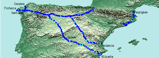
Like Charles Estienne's similar guide for France, it does not list all roads, and various parts of the country have no roads at all. It does however have a map, and lists many roads in great detail, with distances in leagues, including the Camino Francés, which corresponds more or less exactly to the route given in the Codex Calixtinus four centuries earlier.
The Reportorio lists two other routes as being to Santiago, from Valencia via Burgos, and from Alicante via Toledo, both of which I have plotted. It also includes other routes to/from Guadalupe and Montserrat; I have plotted the road from Perpignan and Barcelona to Montserrat, but not as yet any of the others.
More details
spreadsheet | detailed map (235 placemarks)External resources
- An interactive map of the roads with Gonzalo Arias's transcription of the routes is available on Isaac Moreno Gallo's Traianus website
- A reproduction of the original map, dated 1543, is available on chinchillademontearagon.com